Affordable Homes
Historic 10-Acre Property in Dollar Bay, Michigan, Listed at $49,900
Historic 10-Acre Property in Dollar Bay, Michigan, Listed at $49,900

Historic 10-Acre Property in Dollar Bay, Michigan, Listed at $49,900
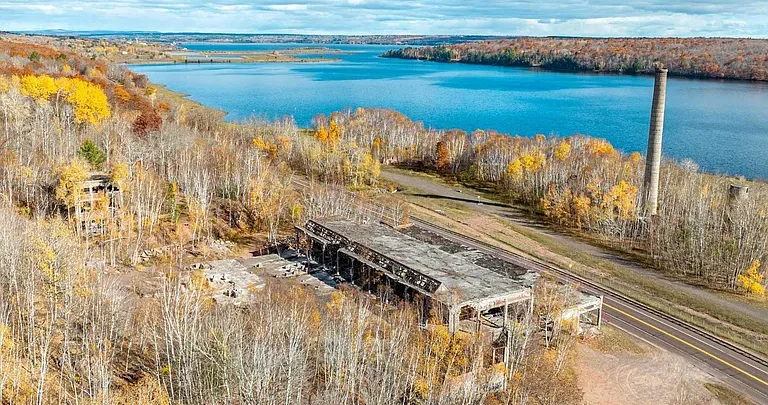
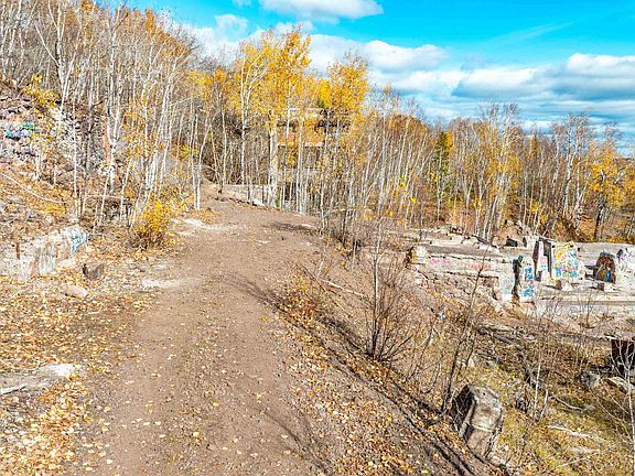
A property with industrial ruins, flowing water, wooded terrain, and trail access offers a different experience from an ordinary vacant parcel. Located at 50415 M-26 in Dollar Bay, Michigan, this approximately 10-acre property is listed at $49,900 and contains remains identified in the listing as part of the former Quincy Mining Company Stamp Mill.
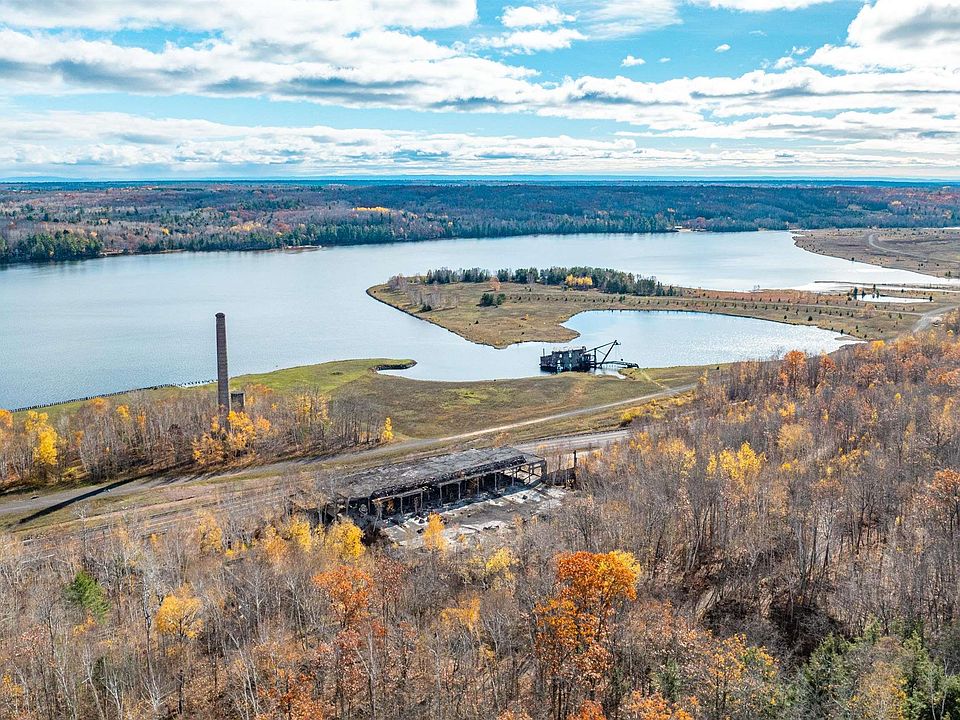
Situated in Osceola Township, the land combines a connection to the area’s mining past with several distinctive natural features. Quincy Creek flows through the property, while elevated portions offer views of Torch Lake. Approximately 680 feet of highway frontage and direct access to Snowmobile/ATV Trail #3 add to its appeal.
This is unimproved land with deteriorating historic structures, rather than a finished residential property. Its character may interest buyers drawn to local history, outdoor recreation, or an unusual landholding. Understanding the site’s condition and limitations is essential to evaluating those possibilities.
Property access is strictly by appointment and accompanied by an agent. The listing prohibits entry without an agent and warns that deteriorating areas may be unsafe.
Property Overview: 50415 M-26
The supplied listing presents the property as a private offering of unimproved land. Its main features include:
| Feature | Listed Information |
|---|---|
| Address | 50415 M-26, Dollar Bay, MI 49922 |
| Asking price | $49,900 |
| Property type | Unimproved land |
| Approximate acreage | 10 acres |
| Township | Osceola Township |
| Historic feature | Remains of the former Quincy Mining Company Stamp Mill |
| Water feature | Quincy Creek |
| Views | Water and lake views |
| Highway frontage | Approximately 680 feet |
| Road surface | Paved |
| Trail access | Direct access to Snowmobile/ATV Trail #3 |
| Terrain | Rolling, hilly, wooded, and partly open |
| Listed utilities | None |
| Listed water service | None |
| Listed sewer service | None |
| HOA | None reported |
| Listed purchase terms | Cash |
These details describe a property whose appeal depends on both its physical setting and its unusual existing features.
A Connection to the Area’s Mining Past
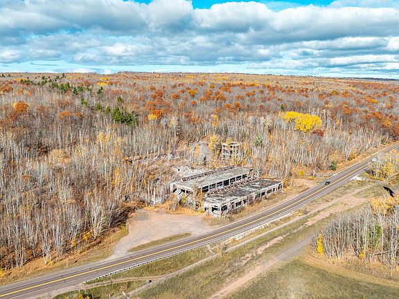
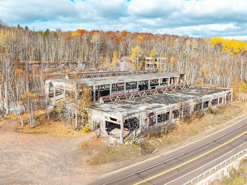
The former stamp mill remains are central to the property’s identity. According to the listing, these industrial structures provide a glimpse into the area’s mining history and distinguish the parcel from surrounding undeveloped land.
For someone interested in historic places, the presence of original industrial remains can create a strong sense of connection to an earlier use of the landscape. The structures give the site a visible story that extends beyond its current classification as vacant land.
The supplied information does not establish construction dates, the precise extent of the surviving remains, or any formal historic designation. Those subjects would require additional documentation.
What the listing does establish is that the historic structures are an important part of the offering. They should be considered alongside the land, creek, access, and overall site condition.
Industrial Character Within a Natural Landscape
One of the property’s most distinctive qualities is the combination of industrial remains and natural surroundings. Wooded areas, open spaces, and changes in elevation share the site with structures associated with its former use.
That contrast gives the property a varied appearance. Different portions may feel enclosed by vegetation, while others may offer a more open perspective on the landscape or surviving structures.
For a prospective buyer, this variety makes an accompanied showing especially useful. Photographs and maps can introduce the site, but they may not fully explain how its features relate to one another.
Understanding those relationships is important when evaluating access, usable areas, and potential activities. The property should be approached as a complex existing site with its own physical constraints.
Approximately Ten Acres With Varied Terrain
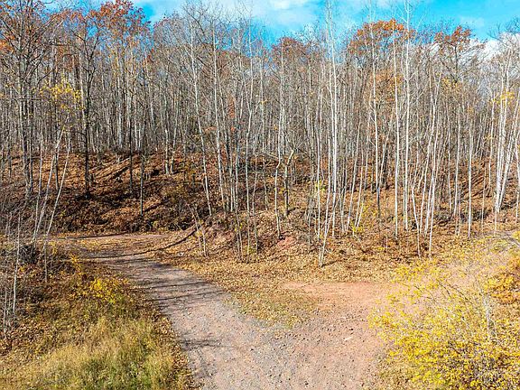
The listing describes the parcel as approximately 10 acres. Its terrain includes rolling or hilly sections, wooded areas, and open spaces.
This combination means that the acreage should not be understood as a uniform expanse of level ground. Slope, vegetation, water, and existing structures all influence how different portions of the property can be accessed and used.
A buyer interested in a particular activity would need to identify which parts of the land could accommodate it. The presence of open space alone does not establish suitability for construction, parking, or other improvements.
A survey and an appropriate site review can help clarify the parcel’s boundaries and physical characteristics. Those details are particularly useful where multiple landscape features and historic remains occupy the same property.
Quincy Creek Flows Through the Property
Quincy Creek is one of the principal natural features identified in the listing. The creek passes through the land, adding a water element to the site’s wooded and industrial character.
Moving water can contribute to the experience of a property through its appearance and relationship to the surrounding terrain. Here, the creek provides another point of interest beyond the historic structures.
The listing does not establish water quality, seasonal flow conditions, fishing opportunities, or permitted uses of the creek. Those details should not be assumed from its presence.
For prospective owners, understanding the creek’s location is also practical. Its course may influence movement across the property and the suitability of nearby areas for any proposed activity or improvement.
Elevated Areas With Views of Torch Lake
The listing states that elevated portions of the property offer views of Torch Lake. Those views add another layer to the landscape and may be an appealing feature for buyers who value a water outlook.
The extent of the view would depend on the observation point, vegetation, and conditions at the time of a visit. It should therefore be assessed from the property rather than assumed to be consistent across the entire parcel.
Importantly, a lake view does not establish lake frontage or access rights. The supplied listing identifies Quincy Creek as the property’s water feature and does not describe direct ownership along Torch Lake.
That distinction helps present the offering accurately: this is land with creek frontage and reported lake views from elevated areas.
Approximately 680 Feet of M-26 Frontage
The property has approximately 680 feet of frontage along M-26, according to the listing. The road surface is identified as paved.
Highway frontage is a practical part of the offering because it establishes a substantial relationship between the parcel and the public road. However, frontage and approved vehicle access are separate details that should be understood clearly.
The listing does not specify the number or condition of entrances, driveway approvals, or the suitability of particular access points for different vehicles.
During a scheduled showing, prospective buyers can examine the existing access arrangement and its connection to the interior of the property. This helps clarify how comfortably the land could support the buyer’s intended use.
Direct Access to Snowmobile/ATV Trail #3
Direct access to Snowmobile/ATV Trail #3 is another feature emphasized in the listing. For buyers interested in motorized outdoor recreation, that connection may be a significant part of the property’s attraction.
A parcel associated with an established trail can provide a different recreational experience from land without such access. It may appeal to someone seeking a personal base for outings, subject to the site’s condition and applicable requirements.
The listing does not establish year-round trail availability or unrestricted use. Current trail conditions, operating rules, and the precise access arrangement should be confirmed before making plans.
The property itself also contains deteriorating structures and potentially unsafe areas. Recreational interest should be considered with those existing conditions clearly in view.
A Location Near Houghton and Hancock
The listing describes the property as a short drive from Houghton and Hancock. That location adds context for buyers evaluating a land purchase in the Dollar Bay area.
Proximity to nearby communities may be useful when arranging supplies, meeting service providers, or planning visits. The practical importance of that convenience depends on how a future owner expects to use the land.
Exact distances and travel times are not supplied. Buyers can check the routes to their own destinations rather than relying on a general description.
Within the information provided, the property offers a combination of wooded terrain, water, historic remains, and road access within reach of the two communities mentioned in the listing.
Unimproved Land With No Listed Utilities
The listing reports no utilities, no water service, and no sewer service. These are important facts for anyone considering a use that would require permanent infrastructure.
An existing historic structure does not establish that usable services are available. Likewise, road frontage does not confirm that utilities can be connected at a particular cost or within a particular timeframe.
The feasibility of any future improvement would depend on more detailed investigation. A buyer would need to understand service availability, site conditions, and the requirements associated with the proposed use.
This information helps define the offering accurately. The property is being marketed as unimproved land with historic remains, not as a serviced residential site or a ready-to-occupy retreat.
Historic Structures Require Careful Evaluation
The listing expressly warns that the property is in deteriorating condition and may contain unsafe areas. This warning is a material part of the property’s description.
The surviving structures may contribute strongly to its character, but their appearance does not establish stability or suitability for entry. The supplied information does not identify any building as safe to occupy, restore, or adapt.
Anyone considering a plan involving the structures would need appropriate information about their condition and the practicality of the proposed work.
The same applies to the wider site. Because it contains remnants of a former industrial operation, buyers should investigate property conditions rather than assume that a particular residential, recreational, or other use is suitable.
Appointment-Only Access With an Agent
The seller’s access instructions are explicit: visitors must not enter the property without an appointment and their agent. Entry without an agent is strictly prohibited.
These instructions apply even if someone is interested only in viewing the ruins, walking the grounds, or taking photographs. Roadside visibility does not create permission to enter private land.
An arranged showing gives prospective buyers an opportunity to learn about the site while following the stated access conditions. The listing also notes that audio or video recording may occur on the property.
Anyone wishing to see the land should contact the listing agent first. The site’s historic appeal and recreational features do not override the restrictions governing access.
Boundaries, Taxes, and Permitted Uses
The supplied parcel number is 00902300105. This identifier can help buyers request information about the correct property, but it does not replace a boundary survey.
The listing specifically explains that GIS images, mapping applications, and plat-book pages are not surveys. This matters when evaluating acreage, road frontage, creek location, and the position of historic remains.
The zoning field is listed as “None,” but that entry should not be interpreted as confirmation that every proposed activity is allowed. Buyers should verify the requirements relevant to their plans.
The reported annual tax amount is $729. The listing warns that taxes may be reassessed after a sale and may change significantly, so the seller’s current amount should not be treated as a guaranteed future tax bill.
Listing Contact and Offer Information
The property is listed by Devin Leonarduzzi of CENTURY 21 Affiliated. The supplied agent contact number is 906-284-2730, and the brokerage number is 906-482-0001.
The offering is identified as MiRealSource MLS number 50226312, with the Upper Peninsula Association of Realtors named as the originating MLS.
The listing requests that buyers allow 72 hours for an offer response. It also states that the seller may set or change offer deadlines and may request pre-approval or proof-of-funds documentation.
Current availability, asking price, showing instructions, and offer requirements should be confirmed directly with the listing agent.
A Distinctive Property With History and Outdoor Appeal
At a supplied asking price of $49,900, this approximately 10-acre Dollar Bay property brings together features rarely presented in the same offering: former stamp mill remains, Quincy Creek, elevated lake views, highway frontage, and direct trail access.
Its appeal lies in that combination. The historic structures give the site an individual identity, while the terrain and water contribute to its natural setting.
The property’s condition and access restrictions are equally central to understanding it. For an interested buyer, a scheduled, agent-accompanied visit and a careful review of the land’s suitability are the appropriate next steps toward deciding whether this unusual Michigan property fits their plans.



From Zillow